Technical analysis · August 2026

Google Map dissected: 72 ranking signals, 395 methods and the architecture linking the Web,
places and AI

From the 2024 leak to Geostore, we rebuilt how Google consolidates a place, measures its importance, understands a query, selects results, draws them on the map and now starts personalising them with AI.

Powered by RESONEO

In 2024, a leak of internal documentation opened a window onto Google's systems. For two years it was the best available source for understanding what sat behind Google Maps.

Since then we have got hold of a recent binary carrying a non-public Geostore scope, then cross-checked that material against Google Maps protocols, its network traffic, its Web index, its adjacent services, its style tables and several locally executed components.

The result noticeably changes the picture one could have of Maps. We now hold message names, field numbers, complete enumerations, hundreds of API methods, ranking signals, indexing structures and measurements taken directly against the engine.

And the timing is interesting. On 6 August 2026, Google announced a wave of AI features in Maps. We had the code from the day before and the day after.

Google Maps is no longer just a map and a local engine. It is becoming an answer engine too. To understand what that shift means, you first have to understand the machine underneath.

Contents

The base
The bridge to the Web
Oyster Rank
Search
Services and the listing
AI and personal context
The map
What it changes

Ten points, if that is all you read

1. Google Maps does not sit on a listings database. At the centre sits Geostore, a far more general repository modelling canonical geographic entities called Feature.

2. A Feature mixes information from different sources. Provenance can be kept at field level. Name, phone, a category or a geometry can each have a different origin.

3. When sources disagree, they get arbitrated. Geostore exposes conflation, priority, trust, rights, and even the criteria a future edit must meet to replace an existing value.

4. Geostore has its own rank system, and it has a name. Oyster Rank. We recovered the complete visible enumeration of 72 signals, 25 of them explicitly deprecated. The signals present include reviews, Web query volume, listing impressions, listing opens, direction requests, clicks to the site, chain membership, popularity, prominence and road usage.

5. We have the signal names, not their coefficients. The schema states they are combined with weights, but the fifteen most interesting fields of RankDetailsProto are stripped from the scope we could recover.

6. That rank is not the final ranking of a Maps query. Search/Places then adds semantic understanding, geographic context, candidate generation, relevance and serving.

7. The Web and Maps are far more tied than they look. Web documents are attached to entities through their MID, with topicality, confidence and geographic metadata stored in the index. One layer, Webref, decides document by document which entity a page is about.

8. The engine is not a distance sort. In dense areas we observe a target of 20 results and a radius that adapts to the query. In Paris, 0.98 km is enough for pharmacie, against 12.44 km for Carrefour. The same pharmacie query is 32.96 km in rural Lozère.

9. Part of the geographic intelligence is computed on the phone. An embedded layer infers frequent places, home, work, trips and a ChainAffinity, an affinity towards a retail brand. Mind the evidence level: the segmenter stage is named, the persona stage is not.

10. The AI announcement of 6 August 2026 is mostly a server-side switch-on. Of the six announced strands, five have no new code counterpart. The only genuinely new code is the consent service, because it is the one brick you cannot switch on remotely.

How we worked

Three levels of evidence, held from start to finish. This is the reading grid for the whole study.

Declared in the schemas

A field name, a number, an enumeration or a comment establishes that the system provides for that information.

If SIGNAL_GOOGLE_REVIEWS exists in the rank enumeration, we can state that reviews belong to Geostore's rank vocabulary. We cannot infer their current weight in a search.

Observed in the field

We queried the services, captured responses, compared rankings, varied location and zoom, decoded tiles and measured the results.

At this level we can state that the engine returns 20 results under some conditions, or that the priority carried in the tile exactly mirrors the result order.

Unknown boundary

When data is missing, we say so. That matters most for the ranking weights.

The point of this study is not to turn internal names into SEO mythology. It is to separate what the data demonstrates from what it cannot tell us.

The data, in the open

10,936 Geostore declarations, searchable and downloadable

Messages, fields, complete enumerations, tags removed from the client scope, and the March 2024 prose alongside. A search engine to dig into types, attributes and signals, and a full dump for those who would rather use their own tools.

Open the archive Download everything
01

What changed since the 2024 leak

The documentation recovered in 2024 had a rare quality: it explained the role of thousands of models and attributes, in prose.

But it had a weakness.

Its enumerations were largely abstract. We could grasp the concepts, far less easily rebuild their actual values.

The recent binary changes that.

Corpus at a glance
 1 623  protobuf descriptors
 4 013  messages
 1 359  enumerations
17 757  enumeration values
   433  Geostore types (300 messages + 133 enums)

Among the large enumerations recovered:

RankSignalProto.Signal              72
RankDetailsProto.SignalMixerType    35
FeatureProto.TypeCategory          371
EstablishmentProto.TypeCategory    374
DataSourceProvider.Provider        793
SuggestSubtype                     852  in the version we measured
localsearch.lite.IntentType        446

The comparison with 2024 is more instructive still.

Out of 3,585 enumeration values compared, 3,471 could not be found in the 2024 archive, including 70 of the 72 rank signals. Conversely, no Geostore model documented in 2024 has vanished from the recent corpus.

So this is not a new architecture replacing the 2024 one.

It is more as if we had obtained the wiring diagrams of a building whose rooms we already knew.

02

The first thing to unlearn: a Google Maps listing is not a row in a database

A useful mental model of Google Maps starts with a distinction.

Geostore is not Google Maps.

Geostore is the layer that maintains the identity and canonical state of a geographic entity. Search and Places come afterwards.

A Geostore Feature can be:

an establishment
a city
a country
a road
an intersection
a building
an area
a station
a transit element
a 3D object
… and many other kinds of spatial entity

So the POI we see in Google Maps is only a projection of a much richer object.

Anatomy of a Feature
excerpt from the recovered FeatureProto
message geostore.FeatureProto {
  id                                = 1;
  bound                             = 2;
  rank                              = 3;
  name[]                            = 4;
  address[]                         = 5;
  point[]                           = 6;
  polyline[]                        = 7;
  polygon[]                         = 8;
  child[]                           = 9;
  center                            = 10;
  source_info[]                     = 12;
  related_feature[]                 = 13;
  parent[]                          = 14;
  type                              = 15;
  synthetic_geometry                = 16;
  access_point[]                    = 17;
  geometry_precision_meters         = 20;
  rank_details                      = 24;
  covering                          = 26;
  data_source                       = 33;
  establishment                     = 51;
  status                            = 67;
  website[]                         = 69;
  raw_gconcept_instance_container   = 70;
  internal                          = 71;
  social_reference                  = 74;
  knowledge_graph_reference         = 75;
  kg_property[]                     = 79;
  business_chain                    = 91;
  operations                        = 103;
  experimental_data[]               = 118;
  feature_originators[]             = 123;
  existence_confirmations[]         = 126;
  metadata                          = 300;
}
104 fields visible in this scope, 25 slots stripped. A stripped field leaves its tag number behind: that is how the missing ones get counted.

Field 70 deserves its full name: raw_gconcept_instance_container. It is not a list of categories, it is a container of concept instances. That nuance carries everything that follows about categories.

03

An entity has an identity separate from its position

Geostore's fundamental identifier is made of two 64-bit values:

FeatureId
├── cell_id   64 bits
└── fprint    64 bits

The cell_id roughly corresponds to the Feature's position when it was created.

That detail matters.

It must not be read as the current position of the business. The real geometry lives elsewhere in the Feature.

And it is not a two-branch alternative. The schema describes three states:

1.  exact cell            position at creation time
2.  randomised cell       entities with no place of their own
3.  field absent          "As of Mar 2017, the cell ID
                           field of the feature ID
                           might not be set"
The third state is the one that breaks tooling: an identifier may carry no position information at all.

This separation lets an entity move, be corrected or change geometry without losing its identity.

It also explains the various identifiers one meets around Maps.

IdentifierWhat it stands for
Feature ID / ftidthe Geostore identity
Place IDa serialisation of that identity
CIDthe Feature's fprint
MIDthe entity identity in the Knowledge Graph
gcida semantic classification
merchant listing identifierthe listing administered by the business owner

That 64-bit pair is exactly what public tooling handles without naming it. An ftid such as 0x47e66e2964e34e2d:0x8ddca9ee380ef7e0 shows the cell_id then the fprint in hexadecimal; the CID is that same fprint in decimal; and a Place ID starting with ChIJ is its serialised, encoded form. Three spellings, one Geostore identity.

The distinction is fundamental for local SEO. The business, the owner-managed listing, its semantic type and the Knowledge Graph entity are not the same object.

Oyster, the internal name

Geostore is Google's own name for it: it is the prefix on every type in the schema, geostore.FeatureProto. In the documentation that repository carries a second name: Oyster.

It shows up on the identifier, on the entity type on the index side, and above all on the rank system itself.

// on the identifier
the oyster feature id

// on the entity type, index side
RepositoryWebrefOysterType.featureType
  "a value of the enum geostore.FeatureProto.TypeCategory"

// on the rank system
RankSignalProto.rank
  "A value in the range [0, 1] estimating Oyster Rank
   according to this signal."

So the system whose 72 signals we detail further on, Oyster Rank, has a name, and it is not PlaceRank.

04

Google builds a truth out of several sources

A common intuition is that a listing belongs to one source.

source = Google Business Profile

That is not the model Geostore describes.

Provenance can be attached at field level.

Name --------------------- Source A
Phone -------------------- Source B
Hours -------------------- Source C
Category ----------------- Source D
Geometry ----------------- Source E

For a field path, Geostore can keep:

field_path
provider
dataset

The catalogue we recovered holds 793 providers. It includes mapping sources, automated Google pipelines and internal human editing.

So a human correction sits inside the same general philosophy: an observation from a source that carries a priority and a trust level, rather than a magical truth standing outside the system.

DataSourceProvider.Provider 793
05

When two sources disagree: conflation

This is one of the most useful findings for understanding Maps.

The schema exposes three generic methods:

CONFLATION_PICK_FIRST_VALUE
CONFLATION_UNION_CSV
CONFLATION_SUM

And the default value is:

CONFLATION_PICK_FIRST_VALUE

In other words, inside this generic mechanism, when competing values exist the system does not necessarily make the sources vote.

It can simply take the first admissible value in priority order.

That makes source priority an essential piece of data.

This mechanism does not prove every Google Maps attribute is consolidated this way. It proves Geostore explicitly holds this merge machinery.

For a business owner, the consequence matters

Changing a value in Google Business Profile does not necessarily mean:

old value
    ↓
new definitive value

The model looks more like:

new observation
      +
observations already known
      +
provenance
      +
priority
      +
trust
      ↓
canonical value

That is a difference in kind, not in degree.

06

Google also models trust and edit resistance

The trust level visible in the schema has six steps:

UNKNOWN          0
BLOCKED         16
NOT_TRUSTED     32
YP_FEEDS        40
TRUSTED         48
SUPER_TRUSTED   64
YP_FEEDS means yellow-pages feeds: data bought from or ingested from business directories. It ranks above an unknown source, below a source deemed reliable.

But the list is not the interesting part.

For an outgoing Feature, the trust structure can also define the criteria a new edit must meet to be accepted.

So an attribute can conceptually carry three different properties:

Where does it come from?
PROVENANCE

How reliable is that source?
TRUST

What level must a future edit reach
to replace it?
EDIT BARRIER

That third dimension explains why some map errors are hard to correct, even when you go about it properly.

We did not recover the formula. TrustSignalsProto holds four slots stripped from the scope.

07

Categories are not mere labels

Google separates several levels.

1. The structural type

The Feature belongs to one of 371 structural categories.

FeatureProto.TypeCategory 371

2. The legacy establishment type

A second taxonomy holds 374 values. But its own documentation states it is deprecated in favour of GConcepts.

EstablishmentProto.TypeCategory : deprecated in favor of gconcepts 374

3. GConcepts

This is the ontological layer.

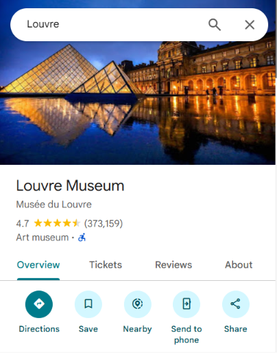
The schema's gconcept_id is the gcid: carried by engine responses. And it is not hidden data: it is the category you read under the business name inside Google Maps. When the Louvre listing shows “Art museum”, that is gcid:art_museum. When a restaurant shows “Ramen restaurant”, that is gcid:ramen_restaurant.

Attributes follow the same convention: AttributeIdProto.id is described as “a stripped format of the gcid”, while an enumerated attribute value is itself a gcid, such as gcid:attval_yes.

Categories, attributes and their values live in one namespace.

A concept can carry a prominence:

NON_PRIMARY  =    0
PRIMARY      = 1000
Two values, not a scale. GConcept prominence is binary.

The documentation gives the example:

"a gas station with a convenience store and an ATM. All three GConcepts are highly relevant, but gas_station is the most prominent."

Traffic confirms the reading. The served gcid list puts the primary category first, then the 8 to 16 secondary ones in strict alphabetical order, on 6 entities out of 6.

The alphabetical sort is the proof that no semantic order travels with the list. The Louvre listing carries 16 values: the first is the one displayed, the fifteen that follow run from art to vacances.

The Louvre listing in Google Maps: under the name, the rating, then the label “Art museum”
“Art museum” under the name, and nothing else. That is the first gcid in the list opposite, and it is the only one that reaches the screen.
the 16 gcid served for this entity
gcid:art_museum   ← displayed

gcid:art
gcid:attraction
gcid:culture
gcid:education_and_culture
gcid:entertainment_and_recreation
gcid:establishment
gcid:establishment_poi
gcid:feature
gcid:museum
gcid:places_of_interest
gcid:public_api_establishment
gcid:tourism
gcid:tourist_attraction
gcid:travel
gcid:vacances
Fifteen values in strict alphabetical order. museum does not sit behind feature because it describes the place less well: it sits behind because m follows f.

The limit follows immediately: there is no gradation between secondary categories. Only the PRIMARY switch is a fact the schema carries.

One last, often counter-intuitive point: the gcid is a property of the search response, not of the listing. It is absent from five GetPlace responses out of seven, which carry the /geo/type/… ontology instead.

One retail brand, two primary categories

This is the most actionable fact in the section. The PRIMARY switch is not uniform inside a chain.

Across 21 stores of the same retail brand in one metro area, matched one to one:

11  gcid:pharmacy
10  gcid:drugstore
These are not places with two categories. They are stores of the same brand whose primary category differs.

Put that next to BusinessChainProto.canonical_gconcepts, which declares “the ideal state of the GConcepts of the members of this chain”, with the isRequired rule: “must be true for a primary gconcept”.

The ideal state is declared. The real state diverges inside the same brand, in the same city.

Ramen example · 1 of 5

One word, several concepts

We will follow one example, the string ramen, from one end of this study to the other. First stop, classification.

The query returns 20 results, and each carries exactly one gcid:

ramen_restaurant               6
asian_restaurant               5
restaurant                     4
japanese_restaurant            4
japanese_authentic_restaurant  1
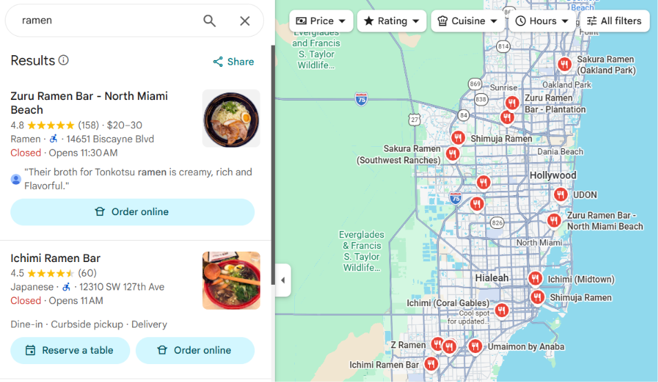
Results of the ramen query in Google Maps: “Ramen” under the first name, “Japanese” under the second
The first two results of the same query already carry two different labels: “Ramen” then “Japanese”. That is the distribution above, as it reaches the screen.

Twenty places surfaced by the same word, spread across five different concepts.

08

The bridge between Maps, the Knowledge Graph and the Web

This is one of the most structuring findings for SEO.

The bridge between Geostore and Google Search's entity ecosystem is not the Place ID.

It is the Knowledge Graph MID.

A Feature holds:

knowledge_graph_reference
         ↓
        MID

On the Web index side, documents themselves carry encodedMid[].

The geographic Oyster ID travels around that entity, but the conceptual pivot is the MID. Its status needs care, and the corpus states the nuance itself: on CountryLocationInfo, oyster_id is a payload “cleared during index creation”; on WebrefMustangAttachment, it is stored. Depending on the message, the same identifier is either carried or kept. A single sentence about its fate would be wrong half the time.

                       MID
                        │
              ┌─────────┴─────────┐
              │                   │
      KNOWLEDGE GRAPH         WEB INDEX
              │                   │
              │         documents tied to the entity
              │         topicality
              │         confidence
              │         document scores
              │
              └──────── GEOSTORE
                            │
                         Feature

The other way round, Geostore does not store each Web page identifier. It gets aggregated signals:

SIGNAL_WEBSCORE
SIGNAL_GOOGLE_WEB_QUERYVOL

The architecture is asymmetric.

The Web knows how to talk about entities. Geostore knows how much the Web seems to talk about them, without becoming a page index itself.

How many MIDs on a listing

A business listing does not carry one MID, it carries a family of them: one per menu dish, one per review topic, one per attribute, plus the brand, the class and the meal types.

Across a capture corpus covering five queries and one full listing, we count 221 distinct MIDs.

The same kind of identifier recurs in several places on the listing, in different roles.

It is those roles that make the listing machine-readable: a menu dish is not a line of text, it is an entity; nor is a review topic.

Ramen example · 2 of 5

The word is not written, it is identified

On a restaurant listing, ramen does not exist as a string. It exists as an entity, and it turns up in three places in three different roles.

the roles of ramen on one listing « ramen » MENU DISH Tonkotsu ramen an entity, not a label REVIEW ANCHOR review #12, chars 48–53 offsets inside the text PHOTO TAG 3 photos tagged by dish and the same review topic recurs from listing to listing listing A listing B listing C a review topic does not depend on the restaurant carrying it

A review saying “the ramen was too salty” is not stored as a sentence. It is stored with the identified topic and the character positions where it is discussed.

That is what lets a system count mentions, attach sentiment to them, and quote the exact excerpt. Without identification, the text would have to be re-read on every question.

09

Webref: how a document becomes evidence about an entity

The boundary between the document world and the geographic world is not a metaphor. It has a name, and it can be counted.

In the 2024 leak, across 14,025 documentation attributes, 25 comments cite a geostore type or path, of which 8 are bridges from outside. Five of those eight sit in RepositoryWebref*.

And what crosses most is not the identifier, it is the entity type: FeatureProto.TypeCategory crosses the boundary three times, through three independent models.

Where representations meet

RepositoryWebrefDomainSpecificRepresentation.entityData declares it can hold:

freebase.Topic
repository_wikipedia.WikiJoin
ocean.WorkMetadata*
geostore.Feature
* ocean is Google's corpus of publications: digitised books, academic and scientific papers. So one entity can be described at once by a Freebase topic, a Wikipedia page, a publication and a place.

Webref is the layer where representations of one entity, coming from different sources, meet.

What the attachment carries, per document
encodedMid[]     "sorted by topicality score"
topicalityE2     fixed point /100
confidenceE2     fixed point /100
oysterId
featureType
latE7 / lngE7    "same format as geostore.PointProto"
A document's MIDs are sorted by topicality. The order carries information.
And the reverse ranking is declared

This is the point SEO should keep. Webref does not merely say which entity a document is about. It also ranks documents against one another, for a given entity.

RepositoryWebrefDetailedEntityScores.docScore
  "relative ranking signal between different
   documents for an entity"

normalizedTopicality   share of the document about the entity,
                       sums to 1 across all entities
connectedness
relevanceScore

isAuthor
isPublisher
isReferencePage
The confidence calibration table

RepositoryWebrefMention.confidenceScore publishes its own calibration. It is worth reading closely, because it lights up every confidence in the corpus.

0,3  →  75 %
0,5  →  87 %
0,7  →  89 %
0,9  →  94 %
1,0  →  98 %
These are not probabilities. They are monotonic ranks heavily compressed towards the top: between 0.5 and 0.9, precision gains only seven points.
And this is where Web SEO meets local

The Knowledge Graph is not fed by the listings.

Webref is the layer that decides, document by document, which entity a page is about, how much, and with what confidence, then ranks those documents against one another for that entity.

A store page does not only compete for a keyword. It competes to be a reference document for the entity.

10

Oyster Rank: the 72 rank signals of Geostore

The system has a name, a complete enumeration, and a sharp boundary where our knowledge stops.

A Feature can carry rank details.

The documented pipeline looks like this:

RAW OBSERVATION
      │
      ▼
SignalExtractor
      │
      ├── raw_scalar
      └── raw_string
      │
      ▼
NORMALISATION [0,1]
      │
      ▼
RankSignalProto.rank
      │
      ▼
SignalMixer
      │
      ▼
FeatureProto.rank

So each signal can carry:

RankSignalProto
type
rank          "A value in the range [0, 1] estimating
              Oyster Rank according to this signal."
raw_scalar
raw_string
metadata
The raw value and its normalised version are separate. A review count is a measurement; its contribution is a value between 0 and 1.

The documentation then states the rank is produced by a weighted sum of several signals.

We recovered 72 values in RankSignalProto.Signal. The enumeration has no reserved_range: it is complete for the scope we hold.

RankSignalProto.Signal 72

Twenty-five of those 72 values are explicitly deprecated. A deprecated value is not a current ranking factor: it is the trace of one that existed.

11

The signals SEOs and businesses will care about directly

The most telling block sits in the 3100 to 3504 family.

SIGNAL_WIKIPEDIA_ARTICLES
SIGNAL_KML_PLACEMARKS
SIGNAL_KML_SOURCES
SIGNAL_GOOGLE_MAPSHOP_USERS
SIGNAL_GOOGLE_RBL_CLICKS
SIGNAL_GOOGLE_RBL_CLICK_FRACTION
SIGNAL_GOOGLE_AUTHORITYPAGE_PAGERANK_CONFIDENCE
SIGNAL_GOOGLE_REVIEWS
SIGNAL_GOOGLE_WEB_QUERYVOL
SIGNAL_GOOGLE_LISTING_IMPRESSIONS
SIGNAL_GOOGLE_INFOWINDOW_VIEWS
SIGNAL_GOOGLE_DIRECTION_REQUESTS
SIGNAL_GOOGLE_HOMEPAGE_CLICKS
SIGNAL_GOOGLE_CHAIN_STORES
SIGNAL_GOOGLE_LEANBACK_TOURS
SIGNAL_GOOGLE_LOCALSEARCH_PLACERANK
SIGNAL_WIKIPEDIA_WIKI_SCORE
SIGNAL_PLACE_INSIGHTS_LANDMARK
SIGNAL_PLACE_INSIGHTS_POPULARITY
SIGNAL_PLACE_INSIGHTS_PROMINENCE
SIGNAL_PLACE_INSIGHTS_APPROACHABILITY
SIGNAL_PLACE_INSIGHTS_TOTAL_ROAD_SEGMENT_USAGE

And a few historical survivors are explicitly deprecated:

SIGNAL_GOOGLE_MAPS_NAVBOOST_CLICKS             [DEPRECATED]
SIGNAL_GOOGLE_MAPS_NAVBOOST_CLICKTHROUGH_RATE  [DEPRECATED]
SIGNAL_GOOGLE_AUTHORITYPAGE_PAGERANK           [DEPRECATED]
SIGNAL_GOOGLE_WEBPAGE_REFERENCE_DOMAINS        [DEPRECATED]
What this list says

It surfaces several families of importance:

PRESENCE AND AUTHORITY ON THE WEB
WebScore, Wikipedia, external references,
authority page confidence
                    +
DEMAND
Web query volume on the entity
                    +
ENGAGEMENT WITH THE LISTING
impressions, listing opens, reviews
                    +
ACTIONS
direction requests, clicks to the site
                    +
COMMERCIAL STRUCTURE
chain membership
                    +
PHYSICAL ENVIRONMENT
roads, approachability, road segment usage
                    +
IMPORTANCE OF THE PLACE
popularity, prominence, landmark character

A place's importance at Google is a hybrid object: Web, cartographic, behavioural and physical at once.

But a caveat follows immediately. We know these items belong to Geostore's rank vocabulary. We do not know their current weight in the final ranking of a Maps query.

12

Popularity and prominence are not the same thing

Google represents them with two different signals:

3501  PLACE_INSIGHTS_POPULARITY
3502  PLACE_INSIGHTS_PROMINENCE

A place can be busy without being an important landmark. Conversely, a monument can carry strong prominence without that notion being the same as its footfall.

Three more signals complete the family:

LANDMARK
APPROACHABILITY
TOTAL_ROAD_SEGMENT_USAGE

APPROACHABILITY — how easily a place can be reached and approached — raises an open question. The name is explicit, we do not have its formula.

TOTAL_ROAD_SEGMENT_USAGE shows something concrete: the road environment around a place can enter its rank vocabulary.

So an entity's rank does not only look at what happens on its listing or on the Web. It can also look at the physical world around it.

13

Where can popularity come from?

We found another piece of the puzzle, this time inside an embedded system layer.

Several pipelines carry explicit names:

deidentified-store-visits
deidentified-historical-busyness
deidentified-wifi-place-visits
deidentified-cycling-activity

They correspond to aggregations of store visits, historical busyness, Wi-Fi-detected visits and cycling activity. The default upload cadence visible in the configuration is 6 hours.

A pulptraining folder also shows this layer takes part in model retraining.

We should be precise about what that proves. We observe:

on-device detection
        ↓
aggregation
        ↓
de-identified upload

And, elsewhere:

SIGNAL_PLACE_INSIGHTS_POPULARITY

We do not have the formula linking the two. The measurement chain exists. The exact causal link to the rank signal is not demonstrated.

14

PlaceRank is not a signal

Another vocabulary trap.

MIXER_PLACERANK appears in an enumeration of 35 mixers. A mixer is the regime used to combine signals depending on the nature of the entity.

For places:

MIXER_PLACERANK = 18
RankDetailsProto.SignalMixerType 35

Two details in this list are worth noting, because they say something about how the enumeration lived. It holds a MIXER_MANAGER at 10000 and five MIXER_TEST_1..5 right after. And values 25 and 26 are absent without being reserved: two mixers existed, disappeared, and left no declared hole.

Conceptually:

Reviews ───────────────────┐
Web query volume ──────────┤
Directions ────────────────┤
Homepage clicks ───────────┤
Popularity ────────────────┤
Prominence ────────────────┤
Approachability ───────────┤
Road usage ────────────────┤
WebScore ──────────────────┤
…                          │
                           ▼
                    MIXER_PLACERANK
                           │
                           ▼
                  importance of the place

So PlaceRank is not “the PlaceRank factor”. It is a mode of combining factors.

15

The part we do not have: the weights

This is the most important boundary in the study.

RankDetailsProto exposes:

signal[]
signal_mixer_type

But 15 further tags were stripped from the scope. The parent field documentation states precisely that this structure holds the signals and their weights.

the door and the key
RankDetailsProto        15 fields stripped
FeatureProto            25 fields stripped
TrustSignalsProto        4 fields stripped
These are numbered holes, not guesses. The compiler leaves the tag number behind.

We do not know:

the coefficients
the normalisation functions
the thresholds
the transformations
the per-market calibrations
the interactions between signals
the model versions
Why this part is missing

Google develops in a single repository, google3, holding the code of almost every product except Chrome and Android. Search, YouTube, Maps, Assistant and Lens live side by side there, and nearly every engineer has access. That is an unusual choice at this scale, and it has its reasons: cross-team collaboration, uniform tooling, feasible large-scale refactors.

A small fraction of the code, around 0.1%, escapes that general access. It is isolated for confidentiality reasons, mainly around anti-spam, and goes by the name HIP, for High-value Intellectual Property. That is where, in 2024, one expected to find components like NSR or PageRankNS.

What we observe here belongs to the same family, one notch lower: descriptors compiled for a client only hold the fields in its scope, and the ones that leave it leave a trace, a reserved tag number.

The hypothesis, which we cannot demonstrate: the most sensitive behavioural signals, the ones whose very existence was debated after 2024, are probably on the closed side of that boundary. The schema does leave an indirect clue, since the two Navboost signals of the geographic vocabulary are present but deprecated: whatever is still active in that area no longer goes by that name, and has been shielded.

We put this forward as a hypothesis, not as a result. What is measured is the location of the hole and its size.

Our analysis of the 2024 leak is here.

16

And above all: this is still not the final ranking of a Maps search

Geostore computes or carries a notion of entity importance. But a Google Maps search asks a different question:

“Out of all these entities, which best answer this query, from this place, right now?”

A more realistic model is:

                   GEOSTORE
                      │
          entity + attributes + importance
                      │
                      ▼
             QUERY UNDERSTANDING
                      │
                      ▼
             SEMANTIC MATCHING
                      │
                      ▼
            CANDIDATE GENERATION
                      │
              ┌───────┴────────┐
              │                │
        importance          proximity
         quality            geography
              │                │
              └───────┬────────┘
                      ▼
                  RERANKING
                      │
                      ▼
                    TOP 20

This is one of the essential separations in the whole study.

Geostore explains very well what a place is and which signals can characterise its importance. On its own it does not explain why that place is number 3 for a given query.

17

Google understands the query before it queries the places

Engine responses expose a semantic classification of the query.

Example observed for a food brand:

fast_food_restaurant   0.913505
restaurant             0.676
hamburger              0.568
breakfast              0.509
coffee_shop            0.367
sandwich               0.348
american               0.287
+ a scored Knowledge Graph entity

A scored geographic hierarchy also travels with the query:

neighbourhood
city
county
state
country
The multilingual test

Our multilingual tests show that synonymous terms in different languages retrieve overlapping entity sets. What happens on the other side is sharper still.

Terms with different meanings do not retrieve “almost no” shared entity. They retrieve exactly zero:

mean Jaccard                     0.0000
pairs compared                    5,193
pairs with non-zero overlap         0%

So retrieval is not purely lexical. The term is first resolved into a conceptual representation, and that representation then steers access to the candidates.

For local SEO the consequence is direct. Having the searched word somewhere is not enough. Google has to be able to link the business to the concepts matching the intent.

Ramen example · 3 of 5

One word, five conceptual destinations

Take again the distribution of concepts seen earlier. Twenty results for ramen, one gcid per business.

Concept carried by the result Results
ramen_restaurant 6
asian_restaurant 5
restaurant 4
japanese_restaurant 4
japanese_authentic_restaurant 1
Total 20

None of these businesses carries all five concepts. The engine did not widen each one’s category: it gathered five different categories around one intent.

And the most frequent one accounts for only six results out of twenty. The concept carrying the typed word exactly is a minority in its own response.

That is why “put the word ramen on the listing” and “be understood as a ramen_restaurant” are two different problems.

18

Local search does not run on a fixed radius

In sufficiently populated areas we observe 20 results. The engine then adapts the footprint needed to get them.

In Paris:

median radius of the farthest result · Paris · same query point
× 12.7
  • pharmacie0.98 km
  • boulangerie1.15 km
  • supermarché5.66 km
  • Total7.24 km
  • Carrefour12.44 km

Same query point, same city. A factor of 12.7 between two queries.

For pharmacie, distance dominates. For a brand or a more ambiguous category, relevance can push the engine much further out while hundreds of businesses sit closer.

And the same query elsewhere

The most telling figure is not in the table. It shows up when you leave Paris with the same query.

pharmacie   Paris          0,98 km
pharmacie   Lozère        32,96 km
A factor of 34 on the radius, for a business density that varies by a factor close to a thousand.

The ratio of the radii is close to the square root of the ratio of the densities. That is the signature of a constant-neighbour-count search: the engine does not search inside a circle, it searches until its twenty slots are full.

Which is why the question:

“What is the Google Maps radius?”

has no single good answer. The radius is partly an outcome of the process, not a fixed parameter set before the search.

19

We also managed to remove geography

An open search surface we instrumented has an interesting property. By omitting the geographic weighting, it exposes a state you cannot obtain with the standard Places API.

We ran:

 5 083  calls
86 584  results

When two lists share the same entities, their order barely moves:

Median Spearman   +1,000
Mean Spearman     +0,984

Moving the origin point by thousands of kilometres barely changes that order.

It matches neither:

the cell_id
the CID
the lexical order of the identifier
a distance to some hidden geographic point

This reveals a very stable non-geographic order behind retrieval.

What we cannot say
observed order = FeatureProto.rank
observed order = MIXER_PLACERANK

We do not have that link. It could be a quality prior, an internal document order, or something adjacent.

The phenomenon is measured. Its exact nature remains opaque.

20

Try the engine yourself

The same call as the previous section, with and without geographic weighting.

48.8566, 2.3522

The surface used here is experimental and undocumented. It should not be confused with the commercial Google Places API.

The geographic parameter we use does not merely define a maximum radius. When weighting is on, geography influences the ranking. Without it, you see the non-geographic order obtained earlier, once geography is removed. The 20-result ceiling holds in both cases.

The radius this form shows will often differ from the median radii measured earlier, and that is not a contradiction: the table gives a median across dozens of origin points, while here you query a single point. For pharmacie in central Paris the median sits at 0.98 km and this particular point climbs to 5.68 km, because three distant pharmacies enter the top 20 ahead of dozens of closer ones. That is exactly the phenomenon of a local search without a fixed radius, and it is more convincing to see it than to read it.

21

Suggest already knows the nature of what you are typing

Before the user even submits a search, Maps calls its Suggest service on every keystroke.

This section does not present a catalogue. It demonstrates one thing.

On every keystroke, the system qualifies what you are typing, and it already knows whether the answer will be local or not.

Across 199 measured suggestions on the map side:

establishment            125
category                  29
chain                     21
locality                  11
local query, web answer   9

The catalogue distinguishes very fine cases. Among the values:

SUBTYPE_MAPS_ESTABLISHMENT_POI
SUBTYPE_MAPS_CATEGORY
SUBTYPE_MAPS_CHAIN
SUBTYPE_MAPS_LOCALITY
SUBTYPE_MAPS_LOCAL_WEB
SUBTYPE_MAPS_POLITICAL
SUBTYPE_MAPS_ROUTE
SUBTYPE_MAPS_STREET_NUMBER
SUBTYPE_MAPS_TRANSIT_STATION
SUBTYPE_MAPS_TRANSIT_LINE
SUBTYPE_MAPS_DISH
SUBTYPE_MAPS_AD
SUBTYPE_MAPS_PLUS_CODE
SUBTYPE_MAPS_LAT_LNG
SUBTYPE_MAPS_SYNTHETIC_PLACEID
SUBTYPE_MAPS_CRISIS
The street number that falls into a hole

For street numbers, the catalogue goes as far as:

STREET_NUMBER
  OUTSIDE_SEARCH_RANGE
  OUTSIDE_MINMAX
  IN_RANGE
  IN_GAP

So Google can represent a number falling into a gap in the known address range. Not a valid address, not an out-of-area address: a third state.

Ask Maps was already in the catalogue
SUBTYPE_MAPS_ASK_MAPS
SUBTYPE_MAPS_ASK_MAPS_PROMPT
SUBTYPE_MAPS_ASK_MAPS_PROMPT_FALLBACK
SUBTYPE_MAPS_ASK_MAPS_QUERY_MIRROR
SUBTYPE_MAPS_ASK_MAPS_QUERY_MIRROR_FALLBACK
This family is present in the catalogue before the feature publicly existed. We come back to it with the AI infrastructure already in place.
Ramen example · 4 of 5

One response, five fates

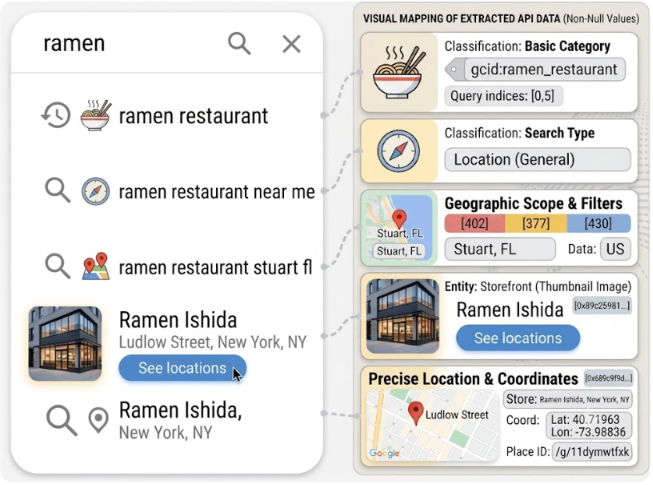
A single autocomplete response on ramen. Every suggestion starts with the same five letters, and no two get the same qualification.

Autocomplete on ramen: suggestions on the left, and on the right the data the response carries for each of them, including gcid:ramen_restaurant, the search type, the geographic scope, the chain entity and the precise coordinates
The first is a category, with its gcid in plain sight. The second switches to a proximity search. The third carries a geographic scope. The fourth is a chain, and its “See locations” is the visible rendering of that qualification. The fifth is a specific business, with its coordinates.

So the “See locations” label is not an interface decision. It is the consequence of a qualification made upstream, at typing time.

22

Google Maps is now a set of hundreds of services

The mobile client talks to a gRPC-over-HTTP/3 service architecture. The catalogue we rebuilt holds 115 services and 395 methods.

Method catalogue

This catalogue shows how misleading it becomes to speak of “the Google Maps engine” in the singular.

Search, listings, the map, UGC, advertising, personal data and AI are distinct layers communicating around shared identities.

23

The final result is not a Feature: it is a composite PlaceProto

When Google returns a result, it does not hand over the Geostore FeatureProto. It builds a much richer serving view.

In PlaceProto we found:

Geostore identity        rating
name                     review count
address                  website
coordinates              opening hours
phone                    main photo
gcid                     MID
ontological attributes   related searches

The full listing then adds:

individual reviews        menus
contributed photos        prices
KG topics inside reviews  questions and answers
busyness by hour          owner responses
and by day                guided taxonomies
                          editorial content

Search and GetPlace use the same place structure, at different fill levels. The client explicitly requests the subfields it needs through a FieldMask.

             GEOSTORE FEATURE
   identity, geometry, provenance,
    categories, existence, ranking
                    │
       ┌────────────┼─────────────┐
       │            │             │
       ▼            ▼             ▼
 Knowledge Graph   UGC        product data
   brands          reviews       menus
   concepts        photos        prices
   dishes          Q&A           hours
   attributes
       │            │             │
       └────────────┼─────────────┘
                    │
             personalisation
                    │
                    ▼
                PlaceProto
                    │
                    ▼
                 LISTING

A Google Maps listing is a document composed on the fly around an entity, not a copy of the geographic database.

24

And the listing already holds objects designed for AI

The content Maps serves goes far beyond the old POI information. We find:

generative summaries
themes extracted from reviews
per-theme sentiment
a relevance score per review
justifications
offsets linking sentences to concepts
confirmed and unconfirmed attributes

That is exactly the material a conversational interface needs.

So Ask Maps does not sit on top of a table holding only:

Name
Address
Stars
Hours

It sits on top of an already heavily enriched and semanticised representation of places.

What that representation looks like

Here is what the response actually carries around one query and one business, laid out flat.

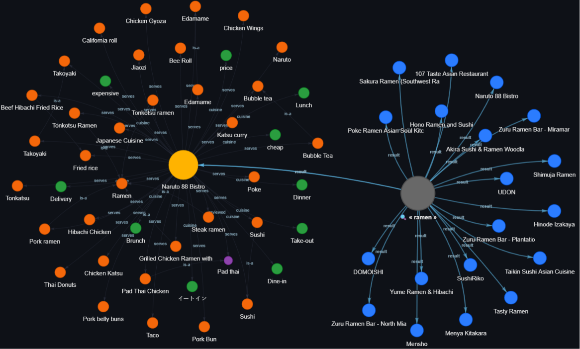
Graph of the ramen query on the right, linked to its results, and of one business on the left, linked to its dishes, cuisines, price ranges and meal times
On the right, the query and the businesses it returns. On the left, one of those businesses, expanded into what it serves, what it is, and when you go. The edges carry their relation: serves, cuisine, is-a.

This is not a listing with fields. It is a neighbourhood of entities linked by named relations, and that is what a natural-language question can be asked against.

Ramen example · 5 of 5

What the agent already reads

The restaurant listing we have followed since the start of this ramen thread carries, with no generative model involved at read time: menu dishes identified by MID, reviews anchored on identified topics with their character offsets, photos tagged per dish, and attributes split into confirmed and unconfirmed.

On another listing in our corpus, a restaurant chain this time, the thematic layer is present and reads directly:

theme "wait time"
  mentions    87
  positive    2
  negative   85

Eighty-five negative mentions out of eighty-seven, and the tally is already done before any question is asked. On top of that, a relevance score per review and justifications with their offsets.

Ask Maps does not invent this material. It reads it.

The example closes here. The string ramen never denoted a keyword. It denoted an entry point into an ontology, and a business wins or loses depending on the concepts the system knows how to attach to it.

25

AI is not arriving tomorrow in Maps: its infrastructure is already there

We had the code from the day before and the day after an announcement. What the diff shows weighs more than the date.

Google presented Ask Maps on 12 March 2026, in an official post: complex real-world questions, personalised recommendations, conversational interaction with the map, initial rollout in the United States and India on Android and iOS, desktop announced for later (source).

Five months later, on 6 August 2026, a second announcement widened the set (source). Six strands:

1  rollout to 160 new countries
2  secure connection to Gmail, Calendar “soon”
3  food ordering partners
4  hotel price comparison
5  opening-hours detection from a storefront photo
6  busyness and transit alerts

Food ordering, meanwhile, was already there in mid-July:

ASK_MAPS_FOOD_ORDERING_AGENT
END_TO_END_ACTION_FOOD_ORDERING

The announcement is almost entirely a server-side switch-on of infrastructure shipped earlier.

What the catalogue already carried
FetchLlmResult
GetKnowBeforeYouGoSummaries
CallKnowBeforeYouGoAgent
PrototypeCallAskMapsAgent
PrototypeCallAskMapsAgentStreamed
CreateSharedAskMapsHistoryThread
GetSharedAskMapsHistoryThread

This lets several functions be told apart:

GENERATION       →  LLM results
AGENT            →  Ask Maps
MEMORY           →  conversation history
PLACE CONTEXT    →  Know Before You Go

So Ask Maps is less a chatbot placed in front of Maps than a new interface onto the semantic, geographic and transactional layers already present.

26

Personal Intelligence is visible inside Maps too

One telling value appears in the code:

PERSONAL_INTELLIGENCE = 45   out of 138 listing content types

We also find a service:

personalitem
  ListPersonalPlaces
  UpdatePersonalIntelligence
  UpdatePersonalNotes

And several sources carry unambiguous names:

KBYG_GMAIL_FLIGHT_RESERVATION
KBYG_GMAIL_HOTEL_RESERVATION
KBYG_GMAIL_RESTAURANT_RESERVATION
TIME_TO_LEAVE_FOR_GMAIL_*
KBYG = Know Before You Go

Another configuration, PLACESHEET_PERSONAL_INTELLIGENCE_MODULES, shows this layer can feed modules of the listing itself, not just a conversational answer.

Google's public framing goes the same way: Search services, Maps among them, can, with user consent, access applications like Gmail, Calendar and Google Photos in order to produce more personalised experiences.

Two people can now look at the same geographic entity without receiving exactly the same informational composition around it.

27

Google computes part of your geography directly on the phone

The received idea is that everything happens between the phone and the server, the first sending a query and the second returning an answer:

phone
   │
   ▼
Google server
   │
   ▼
response

An embedded system layer reveals another storey. Part of the geographic intelligence is computed locally on the device.

We found two large layers.

CSL / segmenter

This stage is tagged: 102 named messages, numbered fields. We read the names directly.

SemanticSegment
Visit
PlaceCandidate
PlaceInfo
MobilePlacePopularity
CslStateSnapshot
DeviceGenericPersona
PULP / HULK

This stage is compiled to WebAssembly. Its 85 parsing tables are located and their exact tags known, but none is nameable: we know type names from RTTI, not the type-to-table mapping.

PulpCalculationInputs
FeatureWeights
Persona
ChainAffinity
UserLocationProfile
FrequentPlace
FrequentTrip
PlaceAggregates
AliasedLocationLite

The distinction matters. On CSL we can cite a message name and say it exists. On Pulp we can say an 85-entry table exists and give its tags, without being able to claim that a given table corresponds to a given type.

28

Pulp literally builds a geographic persona

The visible pipeline looks like this:

LOCATION SIGNAL
        │
        ▼
POINT-BY-POINT INFERENCES
        │
        ▼
SEGMENTATION
        │
        ▼
BEAM SEARCH
        │
        ▼
SEMANTIC SEGMENTS
        │
        ▼
VISITS / CANDIDATE PLACES
        │
        ▼
PULP / HULK
        │
        ├── home
        ├── work
        ├── frequent places
        ├── frequent trips
        ├── travel modes
        └── persona

The profile holds:

Persona
├── ChainAffinity
├── LocationAffinity
└── TravelModeAffinity

FrequentPlace
FrequentTrip
Visit
Activity
PlaceCandidate
SemanticSegment

The most striking field for brands is this one.

Persona.ChainAffinity

A user's affinity for a retail brand can be computed and kept as a piece of their local geographic profile.

This must be told apart from a universal ranking factor. It is an on-device personalisation value.

But for understanding where Google Maps is heading, it is an architectural signal.

29

Even home and work go through place semantics

The home/work labelling component hard-codes a series of category identifiers.

housing              indoor_lodging
residential_area     guest_house
apartment            motel
apartments           luxury_hotel
apartment_complex    budget_hotel
condominium          resort_hotel
student_housing_...  boarding_school
building_society     college
cottage_village      university
                     kindergarten
                     library
                     station
                     transit

And right next to them appear states such as:

tp-poi-suitable-for-home
tp-poi-not-suitable-for-home
tp-poi-suitable-for-work
tp-poi-not-suitable-for-work
tp-no-prominent-category

So the semantic nature of the place takes part in deciding whether it is plausible as a home or as a workplace.

The last value is worth reading twice: tp-no-prominent-category. A place with no prominent category is an explicitly handled case, not a forgotten one.

30

There is also a second scorer, entirely offline

This scorer must not be confused with the 72 Geostore signals. It belongs to the embedded search engine and is not used when the ranking comes from the server.

Its structure:

  8 signals
× 13 tiers
+  8 bases
─────────────
112 functions

Four dimensions of its main family could be characterised experimentally:

CodeObserved behaviour
c-Lbaseline local prominence
c-Rtextual match between query and name
c-Ccategory match
c-Aaddress and position component

The tier depends on the viewport scale. When we vary zoom only, every signal changes tier together.

That gives one more separation:

GEOSTORE RANKING
72 signals, entity importance
              ≠
PLACES SERVER RANKING
query + geography + relevance
              ≠
CLIENT OFFLINE SCORER
8 signals × 13 tiers

So speaking of “the Google Maps ranking” as one formula hides several different mechanisms.

31

Being ranked is not yet being visible on the map

One last step remains. Even if an entity exists and is a candidate, Google must decide what will actually be written on the map.

The mapcore rendering engine is shared across several environments. We recovered a table of:

50 998 styles
12 936 label styles

A style can change with zoom. The mechanism for text appearing is simple:

font.size = 0
      ↓
label invisible

font.size > 0
      ↓
label displayable

Across 1,386 styles starting at zero size, the appearance levels vary widely. And 593 styles never become text, at any zoom we studied. They stay as representations with no written name.

One example that makes the mechanism concrete

On global style 7557, “Restaurant & Bar”, the two zoom entries are identical field for field, with one exception:

style 7557  “Restaurant & Bar”
  zoom  0     font.size =  0 px
  zoom 11     font.size = 11 px

  every other field: identical
The switch is the appearance. There is no hidden score threshold at this stage: there is a font size going from zero to eleven.

So the visibility of a business name is not simply:

business score > threshold

The server first assigns a style. That style determines from which zoom its text becomes eligible.

32

The server even hands the order straight to the label engine

Each LabelRenderOp holds:

text
geometry
style
priority rank
CID / Feature ID
alternative representations

On the layer where the 20 search results are injected into the map, we find exactly:

result  #1   →  16383
result  #2   →  16382
result  #3   →  16381
              …
result #20   →  16364

So the server ranking order becomes directly a display priority order for the injected results.

The client receives far more labels than it can display. Its job is then to:

resolve collisions
        ↓
try an alternative representation
        ↓
text
        ↓
icon only
        ↓
drop if necessary

It does not recompute the business relevance. Most of the decision was taken upstream.

33

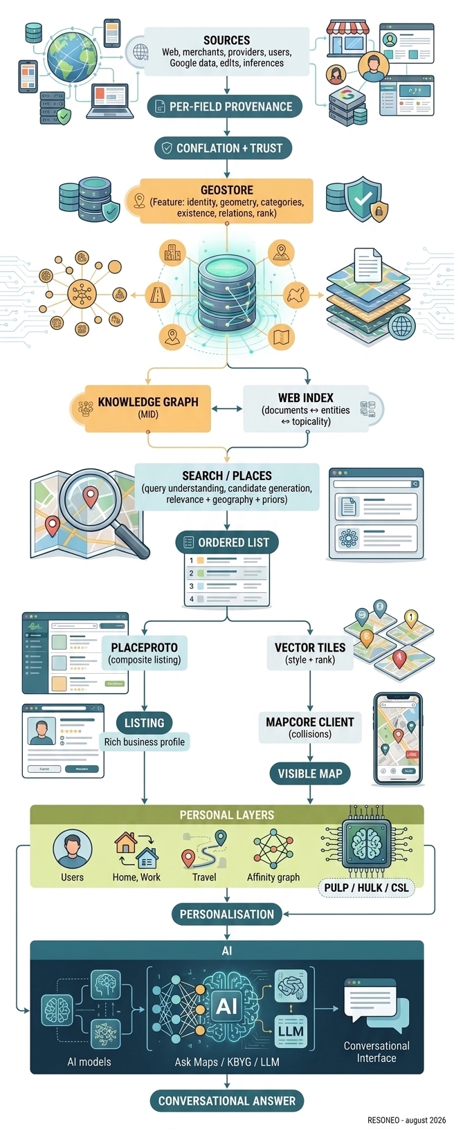
The full picture ends up looking like this

The Google Maps chain rebuilt: from sources to Geostore, from Geostore to search, from search to the visible map, then to the personal layers and AI
The Google Maps chain, rebuilt — from sources through to the conversational answer. Open full size

So the right way to think about Maps is no longer:

PLACES DATABASE
    ↓
ALGORITHM
    ↓
RESULTS

but:

TRUTH SYSTEM
       +
ENTITY GRAPH
       +
DOCUMENT INDEX
       +
SEARCH ENGINE
       +
MAP ENGINE
       +
EMBEDDED MODELS
       +
PERSONALISATION
       +
GENERATIVE AI
34

What this changes for SEOs and retail brands

It would be tempting to turn the 72 signals into a new ranking-factor checklist. That would misread the study.

The most important lesson is architectural.

1. Stop thinking “listing”, think “entity”

Google tries to build a coherent identity of the place across:

Maps · Knowledge Graph · Web · Merchant data
UGC · geography · chain · history

The first job is to reduce ambiguity around the entity. Name, address, phone, category, URL, brand, establishment and relations must tell the same story.

2. Your website is not disconnected from Maps

The document-to-MID link is present in the index. The page topicality towards the entity is itself represented, and Webref ranks documents against one another for that entity. Aggregated Web scores then come back into the Geostore vocabulary.

A good local page must unambiguously answer:

Which place?
Which brand?
Which address?
Which category?
Which services?
Which products?
Which service area?
Which relation to the other locations?
3. Categories are a semantic layer, not a field

Google reasons with concepts, one primary category and ontological relations. A brand must properly cover its real semantic territory, by supplying enough coherent information for Google to link the place to the right concepts.

One clarification that heads off a bad inference: the schema knows no gradation between secondary categories. Only the switch to primary category is a fact the data carries, and we saw it diverge from store to store inside one brand. Stacking secondary categories to “reinforce relevance” has no support here.

4. Brand demand can count in several places

SIGNAL_GOOGLE_WEB_QUERYVOL explicitly belongs to the Geostore rank vocabulary. In parallel, the query engine can recognise a brand as an entity and attach categories to it.

That reinforces an idea hard to measure in local SEO: awareness and demand around the entity can matter as much as the textual optimisation of its listing.

This is not an invitation to manufacture brand searches. It means local does not live in a silo separate from overall demand.

5. Reviews play several roles

SIGNAL_GOOGLE_REVIEWS exists in the rank vocabulary. But reviews also produce themes, extract sentiment, identify concepts, supply justifications, feed generative summaries and answer conversational questions.

With Ask Maps, a review becomes a corpus of evidence about:

service · product · wait · noise
atmosphere · accessibility · quality
price · dishes · use cases

For brands, review strategy also becomes a strategy of informational coverage.

6. Real-world actions are part of the vocabulary
LISTING_IMPRESSIONS
INFOWINDOW_VIEWS
DIRECTION_REQUESTS
HOMEPAGE_CLICKS

At minimum this shows Google can keep and normalise these interaction families within entity rank. The right goal is not to game them: it is to build a place that naturally generates demand and real actions.

7. A chain is an object in its own right

BusinessChainProto exists. SIGNAL_GOOGLE_CHAIN_STORES exists. Persona.ChainAffinity exists on the user side. Maps tells a chain from a specific business as early as Suggest.

And measurement makes the point concrete: across 21 stores of one brand in one metro area, 11 carry gcid:pharmacy and 10 carry gcid:drugstore as primary category, while canonical_gconcepts declares an ideal state for the chain members.

BRAND ENTITY
      │
      ├── store A
      ├── store B
      ├── store C
      └── store D

For a multi-site brand, both levels need work, rather than treating each listing as an island.

8. Proximity is not enough

Our measurements show a brand query can make the engine search much further than a dense local category. And that the same query, outside a metro area, widens by a factor of 34.

You have to stop reasoning purely as:

"I am 800 metres away, so I should be ahead"

Google balances what the user wants, what exists around them, and the importance and quality of the candidates. Distance is central. It is not sovereign.

That does not mean proximity demand is ignored: it is measured. The 2024 leak documented a clickRadius50Percent attribute, the radius within which half the clicks on a query happen. In other words Google knows, per query, how far its users are willing to go — and that radius is learned, not set.

9. The physical world genuinely counts
APPROACHABILITY
TOTAL_ROAD_SEGMENT_USAGE
ROAD_PRIORITY

A physical address has real properties: access, roads, flows, position, environment, transport. Not everything is optimisable from a CMS.

The best retail location and the best local-SEO location are probably not two entirely independent problems.

10. Freshness and existence are first-class objects

Geostore has states for:

closed · removed · moved · rebranded
duplicate · replaced · spam

It also keeps existence confirmations with their origin and timestamp. So a company must watch duplicates, relocations, former locations, rebrandings, temporary closures and address inconsistencies.

An identity error is worse than a poorly optimised field.

11. Optimise for a place that will be read by an AI

Ask Maps changes the system output. Before:

query
  ↓
list of places

Now:

complex question
       ↓
understanding the need
       ↓
selecting places
       ↓
reading the attributes
       ↓
reading the reviews
       ↓
Knowledge Graph
       ↓
optional personal context
       ↓
synthesis
       ↓
reasoned recommendation

So a business must supply enough to answer questions like:

Which restaurant would suit six people with children and one vegetarian?

Which shop is convenient on my route and still open after my appointment?

Where can I eat quickly near my hotel with good recent reviews about service?

Which shop best matches the brands I already like?

These are no longer category queries. They are problems to solve out of attributes, relations and evidence.
35

The next battle in local SEO will probably be semantic completeness

For a long time local SEO organised itself around three big ideas:

proximity
relevance
prominence

These notions remain useful. But the mechanisms we observed suggest a richer reading.

To recommend a business, the AI has to be able to determine:

what it is
what it offers
where it is
how you get there
who likes it
for which reasons
in which situations
under which constraints
at which time
and with what level of confidence

So the competition is no longer only about the best listing. It is progressively about the best representation of the entity.

36

What the 2024 leak showed, and what the wiring shows

The most important finding in this study is not any single signal.

It is not GOOGLE_REVIEWS. It is not POPULARITY. It is not PROMINENCE. It is not even MIXER_PLACERANK.

It is the whole architecture.

GEOSTORE builds the geographic truth
KNOWLEDGE GRAPH gives meaning to entities
WEBREF / INDEX links documents to entities
SEARCH / PLACES understands the query and picks candidates
OYSTER RANK / PRIORS characterise their importance
SERVING composes the final listing
MAPCORE decides what can appear on the map
PULP / HULK / CSL build part of the personal geographic context
PERSONAL INTELLIGENCE adds the user context
ASK MAPS finally turns all of it into conversation

The 2024 leak showed us part of the blueprints. The recent binary and the measurements taken around Maps now let us follow a large part of the wiring.

And it is probably at the moment Google puts Gemini on top of this infrastructure that such an understanding becomes most useful.

Google Maps is not a local search engine with AI bolted on.

It is becoming a system able to build a representation of the physical world, link it to the Web and to entities, observe it through behaviour, contextualise it for a user, then answer in natural language.

For SEOs and retail brands, that changes the question. It is no longer only:

"How do I rank my listing better?"

The question becomes:

"What representation does Google actually hold of my business, my brand, and what they can bring to this particular user?"

That is probably where the next generation of local SEO begins.

Everything this study quotes can be checked line by line in the archive: 10,936 declarations, the March 2024 documentation alongside, and the full dump to take away.

Explore the archive

Other sources and studies

August 2026 Google Map dissected: 72 ranking signals and the architecture linking the Web, places and AI July 2026 What ChatGPT pulls, what it shows, what it cites July 2026 ChatGPT experiments tracker: what OpenAI tests before rollout July 2026 How your Google phone tracks you to "serve you better" June 2026 3,729,456 Google internal URLs, without opening a single one June 2026 What Google is really building June 2026 Inside Pinterest's algorithm June 2026 How Chrome classifies websites internally May 2026 Tomorrow's AI phone, seen from inside a Google APK May 2026 Ranking of the top Google Preferred Sources More stuffs...
RESONEO